![]()
Flood Risk is Changing in Salisbury
Flood Risk in the UK
Flooding in the UK is a prominent issue for many urban areas as impermeable land surfaces create opportunities for surface water runoff to occur, as water is not allowed to infiltrate into aquifers.
The Environment Agency organises areas into groups, based on the probability of a flood occurring. These groups are known as Flood Zones, and they can range from having high (Flood Zone 3) to low (Flood Zone 1) flood risk.
The outcome of your planning application can be affected by the flood risk for the site - it can be difficult to get approval for developments in Flood Zones 2 and 3.
What is the Salisbury River Park Scheme?
The River Avon, also known as the Salisbury Avon, is a chalk stream flowing through Wiltshire, Hampshire and Dorset. This watercourse continues to put urban communities in Salisbury at risk from flooding.
Wiltshire and Salisbury City Council are working with the Environment Agency and Swindon and Wiltshire Local Enterprise Partnership on the River Park Scheme. This £27 million enterprise is reducing flood risk from the River Avon for 350 commercial and residential properties in central Salisbury.
The project involves, inter alia, widening the River Avon, creation of a new river channel, installation of rock weirs and construction of a new flood wall.
There are 4 main areas where the scheme is being carried out: Ashley Road Open Space, Fisherton Recreation Ground, The Maltings and Central Car Park.
When will Works be Completed?
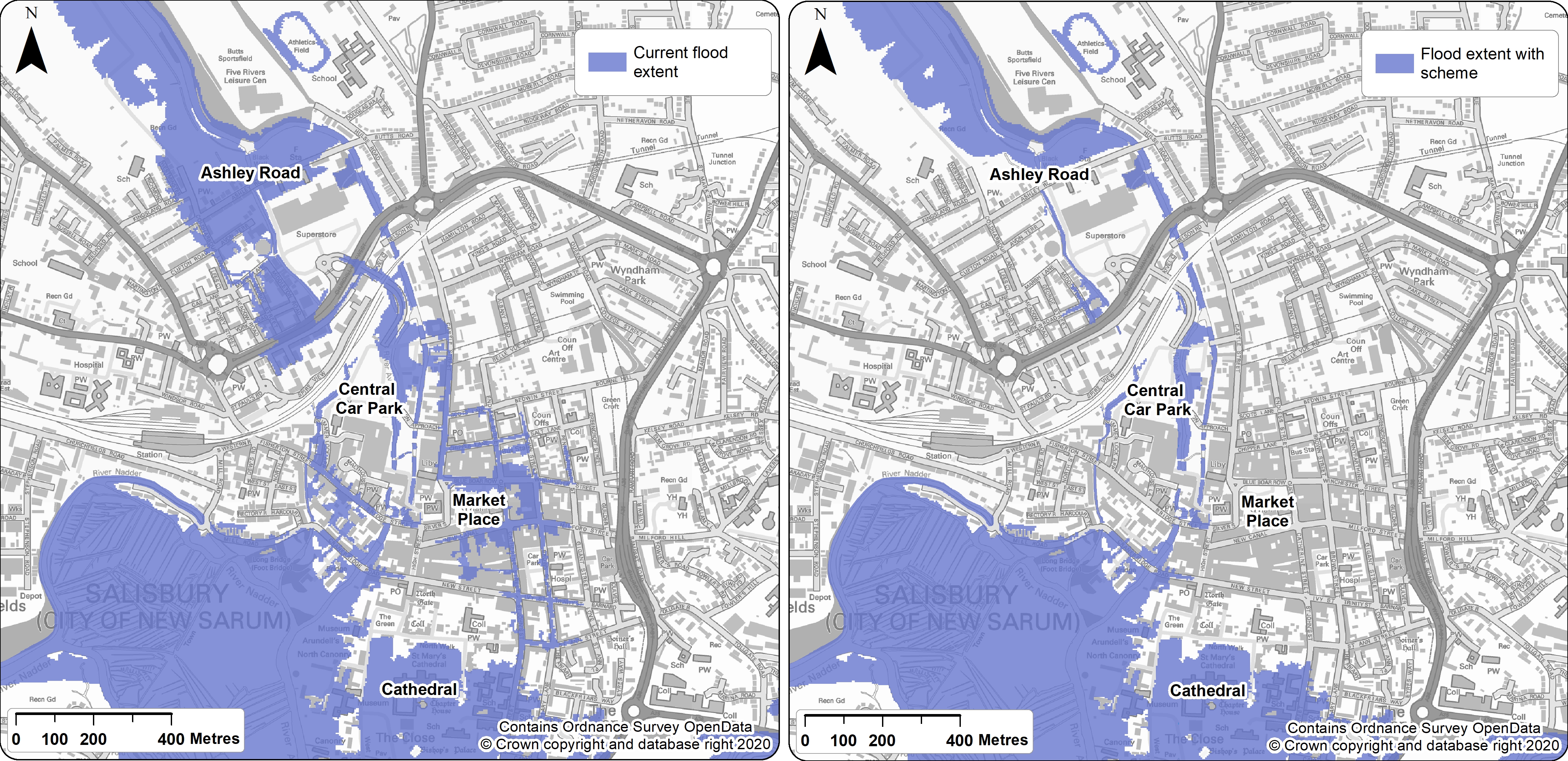
The construction work is scheduled to be completed by the end of 2023. Once concluded, future flood extent will be reduced. Regions of central Salisbury which were previously at high risk from flooding will be less likely to flood.
Click here for updates on the project.
Have Similar Methods Been Used before?
River management is conspicuous in many UK districts. For example, flood defence operations have been completed in Winchester to reduce the risk of flooding from the River Itchen – another chalk stream flowing through Hampshire.
A £42 million flood alleviation scheme has also been approved by Southampton City Council to reduce the risk of flooding from the River Itchen. Construction is scheduled to begin in 2025.
Will this Scheme Impact my Planning Application?
The extensive flood management works could increase your chances of getting approval for your Wiltshire planning application if the Flood Zone for your site changes. For more information, get in touch today!
Click here to view the map extract below.

Map showing flood risk in the centre of Salisbury without the scheme (current flood extent) and with the scheme.
This article was researched and written by our junior planner Alice, who is on a summer placement with us whilst studying for a degree in Geography. If you have ever thought about a career in planning and would like to do a placement with us please get in touch by emailing This email address is being protected from spambots. You need JavaScript enabled to view it.
Share this post